MUTHUH's RIDES - Laconia - Part One
I'm gonna present this trip in three parts; (CLICK ON DATES FOR LINK TO THAT JOURNAL)
1) June 6-9 ~ Durham to Valley Forge, PA - this is the part with my daughter on the Battlefields.
2) June 10-14 ~ Valley Forge, PA to Lincoln NH, and
3) June 15-19 ~ The Laconia Rally and the ride home.

Part One: June 6-9, 2005 The week leading up to this ride was hectic. Work was overloaded, I had to finish up some last minute projects and several clients has asked for rush work prior to my leaving, so the night before, I found myself still unpacked and relatively unprepared for the ride. My daughter had come home from college to spend the night and be there with me in the morning when it was time to go. She studies History in school and was looking forward to 4 days on the bike with me riding through the Civil War Battlefields of the Shenandoah Valley and surrounding areas.
The weather looked dry for these next few days, though the heat appeared to be a concern. Nonetheless, by 9am on Monday morning, I had finished packing, loading and programming the GPS with the routes for the next few days - saving the remainder of the trip for some distant motel rooms. We took a straight northerly route into Virginia under blue skys and moderate temperatures. We stopped in small towns for breakfast and a drug store to get film and lil mom n' pop gas stations for water and gas - generally just meandering our way to Appomattox. I found, on my last ride, a great little approach road from the south, and we putted along enjoying the rolling hills of Virginia.
On the way, as we rounded the bend in the 2 lane road, we saw a sign for Red Hill, Patrick Henry's National Memorial. It was his last home and burial site. Henry, of "Give me Liberty or Give me Death" fame. It wound through the hillsides a good way, making me wonder if we were going too far out of the way.
 Patrick Henry embodied the spirit of American courage and patriotism. He is recognized today, as he was among his contemporaries, as the orator of liberty. His compelling speeches kindled the fires of the Revolution and fueled the effort to secure freedom. Patrick Henry embodied the spirit of American courage and patriotism. He is recognized today, as he was among his contemporaries, as the orator of liberty. His compelling speeches kindled the fires of the Revolution and fueled the effort to secure freedom.
 Henry's was the first voice raised against England in her attempt to impose taxation without representation. He rose to his full stature in attacking the infamous Stamp Act, which was hotly debated at the House of Burgesses in Williamsburg in 1765. The other delegates quailed when Henry hurled defiance at George III with the challenge, "If this be treason, make the most of it." Henry's was the first voice raised against England in her attempt to impose taxation without representation. He rose to his full stature in attacking the infamous Stamp Act, which was hotly debated at the House of Burgesses in Williamsburg in 1765. The other delegates quailed when Henry hurled defiance at George III with the challenge, "If this be treason, make the most of it."
During the second Virginia Convention, his most famous speech was delivered in 1775 at St. John's Church in Richmond. His words became the clarion call that led the colonies into the Revolution. With courage and elegance, he cried, "I know not what course others may take, but as for me, give me liberty or give me death."
We didn't stay long - the heat was building up and the threatened afternoon storms were looming. A little respite in the air-conditioned gift shop and a wander around the property was all we did. In 30 minutes we were back on the way to Appomattox.
I had been here twice before in the last two years, both of those times also on unusually hot days, so I once again feared I would not enjoy the visit. There were old buildings on the far side of the Historic development that I had not ventured out to because of the heat in the past and this time looked like the same thing would happen.
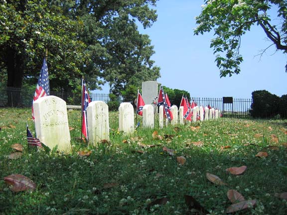
We parked under the big trees near the Fee Booth, not so much for the shade but so the ranger could keep an eye on the bike and trailer, and walked into the recreated Appomattox Courthouse landmark park for our first taste of this hostory tour. My daughter agreed with me on not going to the far sides of the park today - the sun was blistering and there was no breeze and flies were being a pest. Pics #01-04 was our first stop - at the Confederate Gravesite - where a dozen or so soldiers were buried, along with one one Union boy.
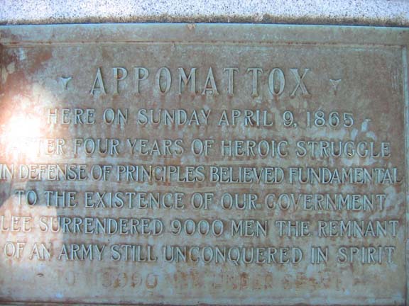
We spend no more than an hour at the park. It was full of school kids and there's only so much to take in - its a small settlement. It does give you an awed feeling to be standing on the same roadways - left pretty much intact and the same as it was in those days (except for no mud and horseshit everywhere) - and feel the energy of the place. At one time figures like Generals US Grant and Robert E. Lee wandered these very roads cementing their place in history. Pic #05 is the recreated Appomattox Courthouse - rebuilt after a fire in the late 1800's. Pic #06 is the town Tavern - always good to know theyhad their priorities straight. Pic #07 is the Lynchburg Road, where on that day in April 1865 the Confederate forces lined up for miles to lay down their rifles and surrender.
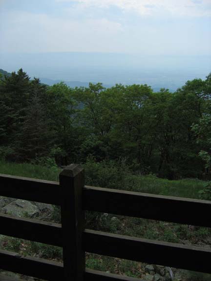
We followed the same general route I took in the opposite direction on my last ride up this way, as we wound our way further north toward Charlottesville. Here we took a short tour of the UVA campus - not all too impressed - and sought refuse from the heat in a small diner for a late lunch. Back on the road, we zig-zagged back roads toward the Skyline Drive just as the afternoon skys darkened for the near daily threat of Thunderstorms we were to experience. Not 10 miles from our destination for the night - Skyland Resort on the highest point of the Skyline Drive - we hit a steady drizzle. Not enough to make us stop, and a small relief from the heat of the day. Pics #09 - 12 are along the Skyline Drive on the way to Skyland.
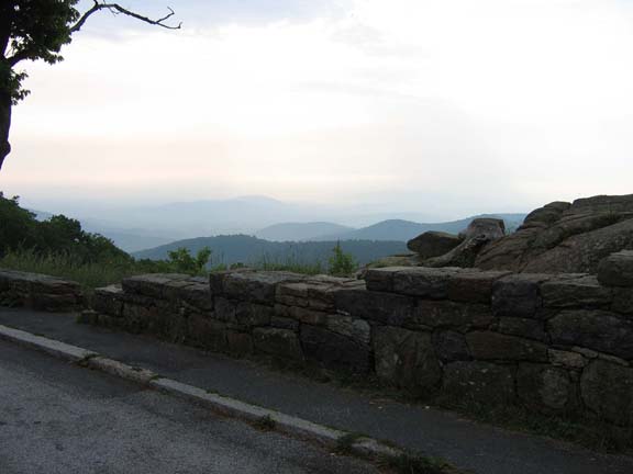
We upgraded our room to a 'valley view' for an additional $10, and sweet talked the lil girl behind the counter into finding us an appropriate room with easy access to the bike - ground floor, parking out front, etc. She accommodates us nicely with a room that has a back porch overlooking the Shenandoah Valley and mountains off in the distance, (#13). At one point, a dear and her fawn parked right outside our porch and stayed for an hour, (#14-15). After a brief shower, my daughter and I went to the Skyland dining room for dinner along the walking paths from our room, (#16).
AFter dinner that night, we were given a great sunset view off the porch that developed into a really spectacular 'heat lightning' display into the night. That thunderhead you see in Pic #17 stayed in place for hours giving us a Chinese Lantern effect well into the evening.
Pics #18-20 were early the next morning as we left the Skyline Drive in search of breakfast in the nearby town of Luray. True to form, I U-turned in town after passing a diner with the name "Jeanne's" proudly displayed over the word DINER... I do have a history of going to restaurants with girls names in them - usually with excellent results - no different this morning either.
While at breakfast, the rather portly waitress, (she did have a good personality though), mentioned we ought to stop across the mountain to the west at New Market Battlefield. I have heard of New Market before but wasn't too familiar with it. So, after eggs and sausage and coffe, we went off our GPS route and headed to New Market, which has a really nice museum associated with it managed by VMI - the Virginia Military Institure. They are involved because it was their cadets, 30 miles or so south of here in Lexington, who came to help stem the battle against the evil marauding Union thugs...hehehe - hey, I'm a southern boy and this is MY story...
After the 25 minute movie - highly recommended - we strode around the battlefield in the morning light. Pic #28, while a serene and picturesque view, is the scene of one of the bloddiest battles of the war that year. It is names the Field of Lost Shoes, because the troops trudging across it after an evening rain turned it to mud and it sucked the shoes off most of the soldiers. Several hundred of both sides died in this field as well. While it wasn't a victory for either side, it did halt the advance of the Yanks and allowed the southern boys to regroup.
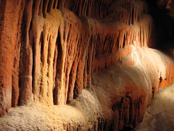
From here we opted for an underground activity, as we were sweating like dogs by 11am. The nearby Luray Caverns are a huge commercial boondoggle, so we continued north a little to the smaller Shenandoah Caverns, and joined about 12 other people on the journey deep under the mountains. Its difficult to choose which pictures to put here because I had about 60 good ones.
It stays a cool 54 degrees year round, so it was a good break from the heat of the day, getting us back on the bike around 1pm. These caves were found in the late 1800's AFTER the battle of New Market, so the armies trampled overhead, never knowing it was here.
Just north of the Shenandoah Caverns on Rt. 11, we pass a sign for a covered bridge, so I did an about face and went down a long straight road (Pic #38) that ended up at this bridge (Pic #37). At the other end of it were two couples on bikes from NC who were wandering around before heading back home. We didn't stay long to chat as we were wanting to get to Harper's Ferry before the exhibits closed. Pic #39 was an old place built in the 1800's now used as the HQ for some local oil company in a small burg we went through. We also did another turn around to go to another battlefield, but after a 3 mile winding through the backwoods found only a roadside marker for a non-descript battlefield. We never got off the bikes and instead stopped at the town's General Store for a cold drink, (Pic #40).
I had heard from somewhere that Harper's Ferry was a historic town and closed to the driving public, so I grabbed a room on the edge of town and changed into shorts and sneakers, and walked with my daughter down the hill to the town. Turns out there's a lot of parking restrictions and limited space, but a bike can easily find places to park in the center of the historic town. Not a big deal - we had a nice leisurely walk talking what fathers and daughters talk about, but got there just as the historic buildings were closing. The Government has bankers hours ya know. Other than some old buildings and what would have been nice to see the inside of the old historic Armory, we didn't miss much - in fact it was quiet and surreal in the long shadows of the setting sun. Harpers Ferry is the site of several turnovers during the war, and could be said to be the first skirmish of the Civil War, when John Brown's Raid occurred several years before the outbreak of the real hostilities. John Brown took over the Federal Armory there and was caught and eventually hung for it, but his insurrection smoldered and eventually festered into the war.
Pic #45 shows some of the classic architecture of this old town, this particular shot being out the back door of the place we found still open for dinner. #46-48 shows where the confluence of the Potomac and Shenandoah River join at the penninsula where Harper's Ferry sits. The bridge abutments shown are from the bridge John Brown used to cross the river in the late 1850's.
Pic #50 is my daughter dipping her toes simultaneously in the Potomac and the Shenandoah Rivers where they meet. Hard to tell from this shot but the two meet directly behind her forming little eddies and runs off to the upper right of the picture as the Potomac River. Next time I come here I'm gonna stay in the Inn shown in Pic #52 - The Hilltop Inn has the best views overlooking the city and the Potomac. From here we walked the long way back to the hotel and watched some of her TV shows... hey it was her vacation, too!
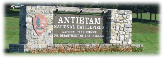 About 20 miles up the road from Harper's Ferry, on a really sweet road called Harper's Ferry Road, we wind our way up to Sharpsburg, MD. This was the battle of Antietam - the singlemost bloodiest day in American History. Gettysburg had more overall killed, but it was over a three day period. At Antietam, On September 17, 1862, 23,000 men were killed or wounded, leading to Lincoln's issuance of the Emancipation Proclamation. This Civil War battle marks the end of General Robert E. Lee's first invasion of the North in September 1862.
After the battles at South Mountain and the fall of Harper's Ferry, the Rebs bumped into the Union Army in the low hills around Sharpsburg. My daughter and I were at the visitor center at 8:30am when they opened and sat through another half hour movie on the battle; wandered the museums; and bought some maps for her walls back home and an Auto Tour Tape. Back on the bike, we drove the 5 mile route, listening to the tape and silently witnessing the locations where so many died. Today, it is a beautiful setting, and except for it being a very hot day again, was a sobering experience. Pic #53 shows the infamous Cornfield where most of the deaths occurred. #54-56 is the Sunken Road where another large number died, 56 being shot from the tower (see below).
|
Want to see an eerie picture? This link takes you to an animation of a photograph taken two days after the battle, showing the dead still lying on the field, and it morphs into the same picture as it looks today. It is 2.0 MB so make sure you are on Broadband before you click THIS LINK. Notice the bullet and cannon holes all over the white church in the background. It is the original structure and many of the floorboards are original.
|
Pic #57 is a picture of a drawing made by some artist during the battle of Burnside's Bridge. This was the location of some fierce fighting at one of the only three bridges crossing Antietam Creek. Note the small Sycamore tree at the eastern base of the bridge...the very same tree still stands at that location, called a Witness Tree. Pic #58 shows the tree 143 years later.
 
At the edge of the Sunken Road, where so many men were killed that day - there is a watch tower you can climb up. It is about 8 twists around the spiral staircase, but well worth the exertion. The view is spectacular, overlooking the Sunken Road immediately below, but also the Cornfield off in the distance - THE bloodiest battlefield in American history EVER. Surpassed only by Gettysburg in the number of killed, but that was over a 3 day period...this was all in one day! I made a panarama shot of the view from up there, You can control the pan right and left with your mouse.
All along the battlefield, you'll find these buried cannons that depict a fallen General. (Pic #61) I don't remember who this one was, but they were scattered all over. After the tour, we stopped off at the Antietam National Cemetery - this was only used for Union dead, as the Confederates were removed over the following days to other locations for burial.
From Antietam, we rode another maybe 60 miles to Gettysburg, PA. By now the heat of the day was awful, approaching 100 degrees. We stopped at the first motel with a vacancy sign, right in the center of the tourist activities, and boarded one of the town trolley cars for a drive around the city. The operator (pic #65) was a nice ol' guy who pointed out stuff along the way - we were the only passengers on the trolley for the entire trip. When he dumped us off at the terminal, we were right across from the Soldier's Museum, so we popped in the air conditioning for a while and wandered around, looking at the diaramas they created of historic battles in the revolutionary and civil wars. Pics #66-67 are a small sampling, note Burnsides Bridge in #67 showing the same historic Sycamore Tree. #68 is the field where the fateful Pickett's Charge took place.
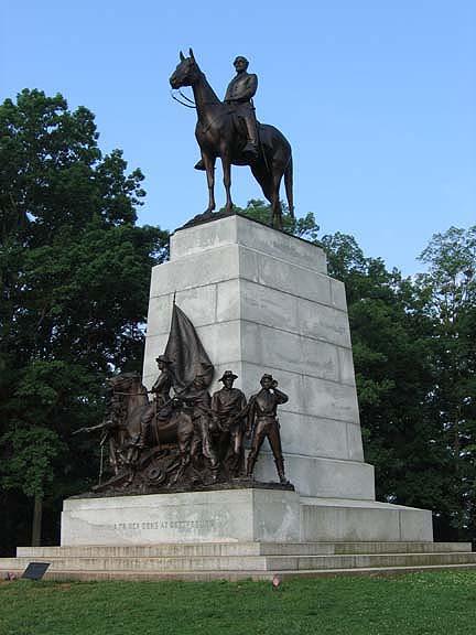
We then boarded an air conditioned bus (see a pattern developing here? It was HOT!) for a tour of the battlefields - a 2 hour trip with a really informative and knowledgable guide (#70). Pic #71 is of one of the hundreds of monuments scattered across this area honoring the various brigades, divisions and states involved in the conflict - the vast majority dedicated to the Union... seems the south wasn't really encouraged to participate in the memorials much until much later years. This one, dedicated to North Carolina, my homestate, tells a chilling tale - that one in every four who fell in this battle was a Tarheel. Pic #72 is dedicated to Gen'l. Lee - he overlooks Pickett's Field and is staring directly at the similar monument across the way dedicated to Gen'l. Meade - the commander of the Union side here.
I mentioned the monuments - as you ride around - you'll notice the really big gaudy obnoxious ones all belong to New York... hmmmmm. The tour guide claimed it was because they had all the money back then - I tend to think it's just because they were New Yorkers! Pics #73-76 are all at Little Round Top, one of the pivotal battles that could have turned the overall battle the other way except for some poor commanding on the side of the Rebs.
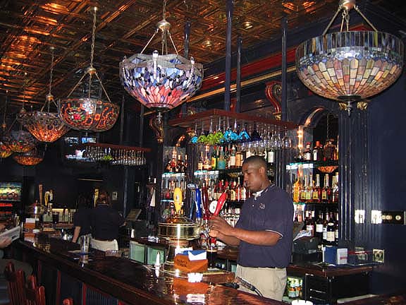
Right downtown in Gettysburg - much of which is still standing as it was in 1863, is a private residence that still holds a cannonball buried in the side of the building...now - my first instict is to think this is a bullshit story, but they all swear it's true. Pic #78 is the hotel where Lincoln stayed right after the battle, and wrote the Gettysburg address, giving the speech in this same sqaure. The Red, White and Blue bunting hanging out that window indicates the room he was in. I was joking with my daughter that I hadn't rolled into any bars yet on this trip, because she was with me (yes she is 21, but doesn't drink...musta inherited that from her mother), so she posed at this saloon as a tease...we went to eat instead.
Right around the corner on the square we found a restaurant with a nice bar - so we comprimised and ate in the saloon side - Pics #81 and 82 are inside that bar. After dinner we went for an evening ride around the battlefields, and ended up at the National Cemetery...spooky place in the dark.
Next morning we rose early, did one last lil' ride through town, mostly to get this picture (Pic #85) showing a bullet-hole ridden building. The tiny window you see at the top of this building was used by Union Sharpshooters. Each hole has been puttied up in white, I think more for visibility from the road. #87 is another view of the North Carolina Monument.
Pic #89 is on our way out of town - the local Harley Dealership, and though I had hoped to do more sightseeing in the Amish Country east of Lancaster, PA... it was so hot and we were short on time. Pics #90-92 are some of this rugged farmland we passed. We did get off the main route and do some back roads, but they seemed more sensible keeping to their homes and barns... we just kept on rolling....
... and by 1:30 - we found our way to Valley Forge after a horrendous traffic jam on a road I shouldn't even have been on - missed the exit. These northern cities are awful for interchanges and ramps and poor signs. I ended up riding along the shoulder for 5 miles till the next exit while the main lanes were dead-stopped. I found a large modern Days Inn with wireless broadband and caught up on work and laundry while my daughter napped. by 3:30pm, we were back on the bke fighting traffic and one-way roads, ending up at the Valley Forge Memorial Park...now, I know this is the wrong war, but we were close and she is into all kinds of history. This was a bit of an eye opener - thinking it would be a simple memorial. In fact it is a 10-mile loop road that we followed with another audio tour tape. Pretty interesting stuff.
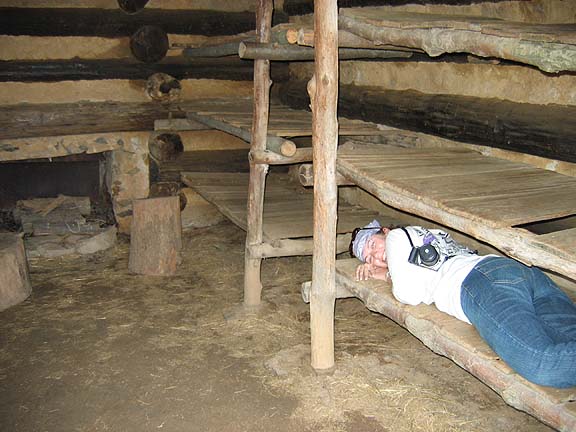
Turns out the winter wasn't really all that severe. of the maybe 20,000 men who over-wintered here with George Washington, it's true that nearly 2000 died, but they were mostly from disease, not cold, and most of them were taken to the hospital 30 miles away before they died. All over are these little reconstructed cabins they built, designed to house 12 men.
Pic #101 is where George Washington and his staff stayed that winter. All of the structure is original, the wood and flooring is partially reconstructed and obviously all of the inside furnishings are period pieces... but interesting to see. I was looking for a sign in Pic #104 that said, "Geo. Washington slept here" but found nothing.
The tour took nearly two hours and included a lot of parkland and dozens of people-friendly deer. No one's ever asked me if a deer shits in the woods before, but now I have an answer (Pic #107)
We had to wake up at 4am the next morning to get my daughter to her 6:30am flight at the Philly Airport, so thats it for the pictures for this section... the next two sections are pretty short, click on one of them for the rest of the journey.
- Muthuh
-->
For Information, contact:
Muthuh@Muthuh.com
Link to other parts of this Journal; (CLICK ON DATES FOR LINK TO THAT JOURNAL)
1) June 6-9 ~ Durham to Valley Forge, PA - this is the part with my daughter on the Battlefields.
2) June 10-14 ~ Valley Forge, PA to Lincoln NH, and
3) June 15-19 ~ The Laconia Rally and the ride home.
MUTHUH'S RIDES HOME |
ARCHIVES |
FUTURE TRIPS
ALL IMAGES COPYRIGHT MUTHUH'S RIDES UNLESS SPECIFIED OTHERWISE
ALL RIGHTS RESERVED.
PLEASE RESPECT COPYRIGHT LAWS AND DO NOT COPY OR USE THESE PICTURES FOR ANY REASON UNLESS WITH WRITTEN PERMISSION. IN ADDITION TO LEGAL PRECEEDINGS, I WILL HUNT YOU DOWN, BURN YOUR BIKE, SCARE YOUR CHILDREN, POST NAKED PICTURES OF YOU AND YOUR OLD LADY AND OTHERWISE MAKE YOUR LIFE A MISERABLE HELL. (Well... OK - I won't burn your bike - THAT's just going a little too far.)
OTHER THAN THAT - HEY! ... HAVE A NICE DAY.
|


